Stabilizing Lake Havasu City’s Washes
A systemic approach to improving highly erosive washes in Lake Havasu City.
Written by: Josh Papworth, PE | Susanna Mabery
Introduction
Lake Havasu City (City) initially developed the roadways and infrastructure to work around the natural topography of the land, restricting washes to align with their originally designated flow patterns. The wash system begins on the eastern side of the City, originating in the Crossman Peak region, extending west, and eventually draining into Lake Havasu. The drainage area encompasses an approximate 12.5% slope from Crossman Peak to the current lake level at the shoreline. As the City developed over time and added to its infrastructure, including impervious surfaces, channelization along the corridors was restricted, leading to increased slopes within the channels. Left unmitigated, erosion concerns created many hazardous conditions.
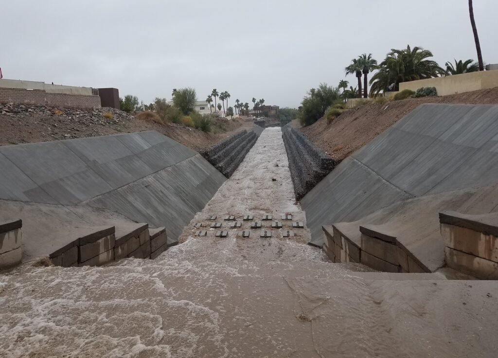
The system of washes that serve the City are primarily unprotected trapezoidal channels that are subject to erosion, scour, sedimentation, and head-cutting due to storm events. Efforts had been made to protect road crossings and construct new culverts at important locations. However, many of these washes, which were originally constructed out of native soils, remained un-reinforced and un-protected against erosion from even minor storm events.
In 2012, a massive storm event occurred, causing $250,000 worth of damage, and took more than six months to repair. At that point, the City decided to take action to mitigate the eroding washes.
Method
In 2015, the City contracted Dibble to develop a Wash Stabilization Improvement Master Plan, to be included in the municipalities Capital Improvement Plan (CIP), to prevent washes from further erosion.
The goals of the project were to create a system robust enough to rank the washes and employ a prioritization method for needed repair that would be easy to implement data and use for future updates. More than 77 miles of washes needed to be analyzed with limited data and funding.
Phase 1 of the project included assessment and prioritization of the wash system. A major factor to consider during this phase was the root cause of the issue – determination of why all of the erosion occurred. Drainage flow is often a result of the natural landforms and processes of the surrounding areas. Man-made changes of building and construction also affect the natural land topography, increasing the impervious areas, and change the watershed response. The established upstream levees diverted flow around the current city limits, channelizing the tributary flow through certain areas. Over time, the slope and limited space for the channels affected the channelization, creating inadequate conditions for the quantity of water flowing through the channels.
Dibble’s Team considered Lanes Equilibrium Balance theory, which evaluates the size of the sediment to the required discharge (flow rate and slope). If these factors are not in balance, a state of degradation (erosion) or aggradation (increase of land elevation due to sediment deposit) will occur. In the case of the wash system, the slope of the channels was too steep, and the washes were in a state of continual downcutting, or downward erosion. Therefore, the slope needed to be reduced to achieve the required equilibrium balance.
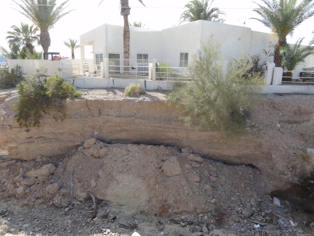
Most washes throughout the City are bound upstream and downstream by road crossings and adjacent to homes in neighborhoods. Water flow wore away at the original slope, which extended spillways. Homes and other structures near the washes faced potential sinking and sliding as the nearby channels got deeper, causing the banks to steepen and encroach on property.
Dibble identified seven risk factors to rank and establish a prioritization matrix for the washes. The risk factors were either a qualitative evaluation or quantitative; quantitative factors were evaluated using HEC-1 and HEC-RAS for modeling hydraulic characteristics.
| Risk Factor | Evaluation Type | Description |
| Streambed Condition | Qualitative | Visual assessment of existing condition |
| Bank Condition | Qualitative | Visual assessment of existing condition |
| Bank Height | Quantitative | Geotechnical Failure Potential |
| Shear Ratio | Quantitative | Erosive potential of the bed and bank |
| Width Ratio | Quantitative | Lateral expansion potential of the bank |
| Proximity Class A | Quantitative | Proximity to Buildings and Roads |
| Proximity Class B | Quantitative | Proximity to Walls and Fences |
Each wash was evaluated using the risk factors and normalized on a 10-point scale. The factors were then multiplied by a weighted value that was dependent on the importance of the factor, the quality of the data collection, and the accuracy of the evaluation method used.
Dibble analyzed the results to ensure that the assessment details matched the data, the expected outcome, and provided reliable results. A priority matrix then ranked the washes from one to 10, with one being the highest risk and in need of immediate stabilization.
Dibble developed a webmap for the City for future use in evaluating and ranking additional washes to stabilize. The webmap can be easily updated using GIS data for each respective wash and inputting the data into ArcMap software.
Plan of Action
After ranking and prioritizing the washes, Phase 2 of the project began. This phase included analysis of a variety of stream protection measures for stabilization to determine the best, most feasible options.
The analysis presented two best options, grade control structures and bank protection. The team evaluated two alternatives for the grade control structures:
- Alternative 1 – Above-Grade Drop Structures
- Alternative 2 – At-Grade Control Structures & Bank Protection
Alternative 1 requires sediment fill behind the structure, use of cement stabilized alluvium (CSA) for the grade drops, and is built up to an equilibrium slope. CSA, a combination of cement and native soil, is an economical solution designed to withstand erosive forces.
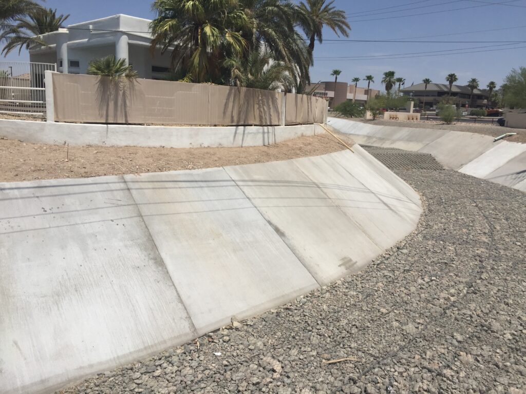
Alternative 2 offers more bank protection, with the erosion occurring down to the equilibrium slope. This option limits the amount of fill needed. Wire tied riprap (gabion baskets) or CSA is used for bank protection. Stacked modular blocks act as retaining walls along the wash channels.
The City chose 10 washes to receive stabilization and added these into the City’s CIP for cost and implementation, to establish a schedule, and ensure funding would be available.
Installation
Phase 3 executed a prioritization matrix that used assessment methodology to determine the worst and most critical washes to stabilize first, as shown in the table below.
| Priority | Wash Name | Recommended Alternative | Planned Project Year |
| 1 | Havasupai Wash 2 | Alt. #2 | 2016 |
| 2 | Daytona Wash 6 | Alt. #2 | 2015 |
| 3 | Havasupai Wash 3 | Alt. #2 | 2018 |
| 4 | Hillside Drain 5 | Alt. #2 | 2016 |
| 5 | Avalon Drain 2 | Alt. #1 | 2017 |
| 6 | Havasupai Wash 6 | Alt. #1 | 2019 |
| 7 | Daytona Wash 4 | Alt. #1 | 2020 |
| 8 | Kiowa Drain 3 | Alt. #1 | 2021 |
| 9 | Havasupai Wash 5 | Alt. #1 | 2022 |
| 10 | Broadwater Drain 1 | Alt. #1 | 2019 |
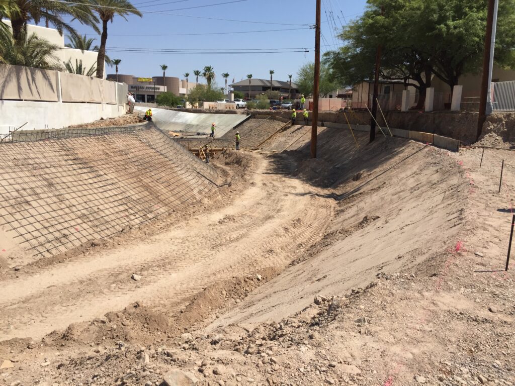
The team encountered design and construction challenges during this phase, including tight wash corridors, and the proximity of homes and existing structures to the top of the wash bank. This made it challenging to get excavation equipment into the area to ensure that stabilization techniques did not encroach on personal property.
Existing utilities in the area presented another challenge. The team made concentrated efforts to avoid the utilities as much as possible. In a few instances, utilities required relocation and close coordination with the utility owners.
Conclusion
The wash stabilization project has created a cost-effective solution for the long-term improvement of the City’s system of washes. To date six washes have been improved:
- Havasupai Wash 2
- Daytona Wash 6
- Havasupai Wash 5
- Hillside Drain 5
- Broadwater Drain 1
- Pima Wash 8
Markets Mentioned
Water+Wastewater
Services Mentioned
Flood Control
This Case Study PDF
Project Manager

Project Details
Project
Lake Havasu City Wash Stabilization
Location
Lake Havasu City, AZ
Market
Flood Control
Owner
Lake Havasu City
Engineer
Dibble
Delivery Method
Design-Bid-Build